Renewable Energy Potential on Federal Lands Analysis
NREL modeled the technical potential for renewable energy development on federal lands—and how much might be developed in the future.

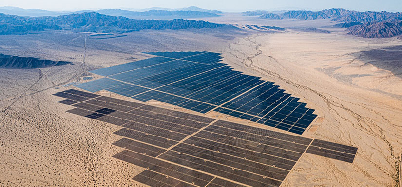
NREL quantified the technical potential of utility photovoltaic (PV), land-based wind, and geothermal energy on federal lands in the contiguous United States. The study also projects the renewable energy capacity to be developed on federal lands—and the associated total and direct land use—under multiple future scenarios. The study found significant renewable energy potential on federal lands, with less than 5% of that land needed for development to meet future energy demands. Read the NREL technical report, Land of Opportunity: Potential for Renewable Energy on Federal Lands.
Study Objectives
Only 4% of operating utility-scale land-based renewable energy capacity—solar PV, land-based wind, and geothermal—in the contiguous United States is currently located on federal lands. For comparison, about 12% of oil drilling in the contiguous United States is on federal lands and the share of total natural gas production on federal lands is similar.
Growing interest in more renewable energy development motivated this study, which was designed to answer two primary questions:
- What is the renewable energy technical potential on federal lands in the contiguous United States?
- How much renewable energy capacity is projected to be developed on federal lands under decarbonization scenarios for the United States?
Technical Approach
NREL used a high-resolution geospatial model to calculate the technical potential or maximum amount of available resource based on the amount of federal land administered across the United States, suitability of the land for energy development, and the energy resource availability.
To ensure realistic assumptions in the model, NREL sought expertise from five federal agencies and land administrators: the Bureau of Land Management, U.S. Fish and Wildlife Service, U.S. Forest Service, U.S. Department of Defense, and U.S. Department of Energy.
Collaboration with these agencies was essential given the diverse public needs that federal lands serve. The technical partnership included data sharing, quantitative and qualitative feedback on assumptions and methods, and a review of the results.
After calculating the technical potential, NREL used a power sector model to determine what energy technologies to build and where across seven scenarios. The scenarios varied in assumptions about technology cost and performance assumptions, renewable siting constraints, transmission availability, and other factors. The wide range of assumptions was designed to capture a broad spectrum of potential future outcomes. Importantly, all seven scenarios achieve 100% carbon-free electricity by 2035 and assume high electrification through 2050. NREL did this to understand the total maximum renewable energy development that could occur.
The power sector modeling results were then downscaled to produce deployment projections on federal lands.
Access the data for geothermal, land-based wind, and solar PV potential on federal lands.

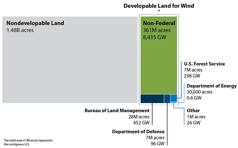
This figure shows the portion of the total contiguous United States land area that is available for wind development. Note that the lands administered by the U.S. Fish and Wildlife Service do not appear because the potential area rounds to 0 acres.

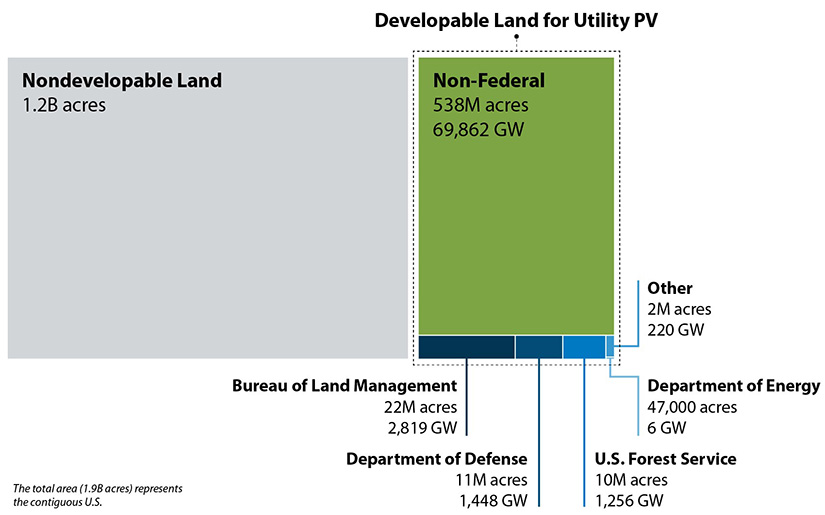
This figure shows the portion of the total contiguous United States land area that is available for utility solar PV development. Note that the lands administered by the U.S. Fish and Wildlife Service do not appear because the potential area rounds to 0 acres.
Key Findings
- In total, there is technical potential for 5,750 gigawatts (GW) of utility PV on 44
million acres of developable federal land, 875 GW of land-based wind on 43 million
acres, 130 GW of hydrothermal on 12 million acres, and 975 GW of enhanced geothermal
on 27 million acres.
- When more stringent siting constraints are applied, the technical potential on federal
lands declines by 70% (to 1,750 GW) for utility PV and by 96% (to 70 GW) for wind.
- There is significant renewable energy potential on federal lands, but only a small
portion would need to be developed to meet future energy demands. In the central scenarios,
51–84 GW of solar PV, wind, and geothermal capacity are deployed by 2035 on federal
lands.
- In most scenarios in 2035, less than 2 million acres of total area would be developed
for solar PV, wind, and geothermal. That is less than 0.5% of all federal land area
and less than 5% of the total land area available for developing these technologies.
Of the 2 million acres that would be needed to meet 2035 demand, less than 815,000
acres or 0.2% of all federal lands would be permanently disturbed.
- Of all federal land administrators, the Bureau of Land Management has the highest renewable energy technical potential, followed by U.S. Forest Service and Department of Defense. The Department of Energy, Fish & Wildlife Service, and other federal land administrators have relatively modest renewable energy technical potential.
Contact
Trieu Mai
Share
Last Updated May 8, 2025
