NREL Wind Researchers Partner with PNNL to Validate ThermalTracker Software and Protect Wildlife

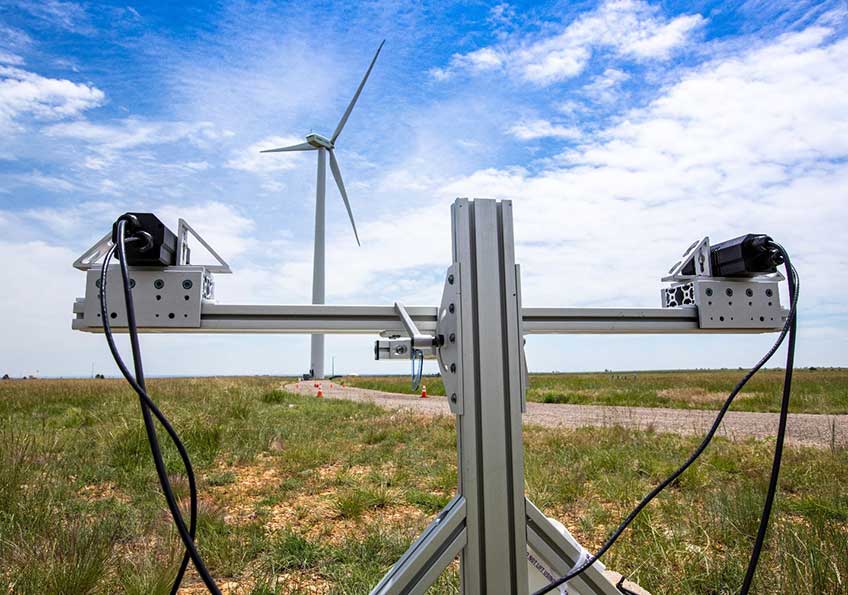
Thermal cameras were used to validate the accuracy of the ThermalTracker software to track wildlife location, flight path, and size. Credit: Werner Slocum, NREL
Minimizing impacts to wildlife from wind energy is a major priority for the National Renewable Energy Laboratory (NREL) and the wind industry. Impacts to wildlife can extend permitting timelines, add unanticipated costs, or constrain generation potential. With wind energy providing about 6% of total U.S. electricity generation and growing, developing cost-effective solutions to detect and deter wildlife from wind energy infrastructure are vitally important.
NREL has a long history of working to understand and resolve impacts to wildlife from wind energy, serving as a founding member of the National Wind Coordinating Collaborative and Bats and Wind Energy Cooperative, and most recently serving as an R&D test bed for early- to mid-stage technological solutions—including one called ThermalTracker.
Six years ago, Shari Matzner of Pacific Northwest National Laboratory (PNNL) began work on what eventually became the ThermalTracker software. What started with the use of a single camera to monitor for the presence of birds and bats has evolved into a high-tech solution that allows scientists to detect the presence of animals from a live feed, identify birds and bats based on characteristics such as size and velocity, and determine whether the animals are flying at the height of wind turbines.
In a new partnership between NREL and PNNL, ThermalTracker is now being validated for the first time ever in the presence of wind turbines. The software uses thermal imaging to detect the presence of birds and bats, and the team is working on enhancements to the software that will allow for more precise identification and tracking of a biological target.
"We're now using a stereo pair of cameras, which allows us to estimate the distance of things in the field of view," says Matzner. "When we know how far away something is, we unlock a lot of other information about it, such as how fast it’s moving and its true size, and that gets us closer to identifying the species. Without knowing the distance, you can’t tell if you’re seeing a large bird far away or a small bird close up as they would appear the same in an image.”
During the first experiment, conducted in the spring of 2019, the team faced snowfall, significant cloud cover, and very low temperatures. While these conditions can present logistical challenges for outdoor experiments, they were also an opportunity to put the system to the test.
“Adverse weather prevented the team from performing as many trials as we had hoped. However, subjecting the system to new environmental conditions was of high value," said Bethany Straw, NREL project lead. "It allowed the PNNL team to understand the limitations of the system and see how it responded to new challenges. It also gave us an opportunity to document some lessons that set us up for a very successful second phase of analysis.”
Phase two assessments were conducted in June after PNNL made some advancements to the software code in response to what they learned from the first phase. “Everything came together for a great week of data collection,” said Straw. "It was honestly beyond expectation. At every point in the process, things just worked in our favor—to the point where Dr. Matzner joked, ‘there is such a thing as too much data.’”
With such a successful campaign, PNNL was able to iterate on the software code to make improvements and prepare the system for a sustained, unattended install.
Following phase two evaluations, the team immediately began preparing for a sustained install, during which the cameras and software was in place for more than two months. The sustained install subjected the system to a new set of challenges to consider and resolve, including how to handle data. For most of the analysis, every piece of data was recorded and saved. Due to the amount being processed, recording and storing all data collected over a prolonged period wasn't feasible. The team had to change the approach to data handling so that only data associated with wildlife events was stored—rather than, for example, scenes of drifting clouds.
The longer install also functioned as a stress assessment; over the extended install period, the ThermalTracker system was subject to shadows, sun glare, and different types of weather, all of which can influence system performance. NREL's landscape and varying weather conditions make it an ideal location to conduct the evaluation. Snow, cold and hot temperatures, and various background views distinct from where the system has already been validated help researchers understand how the system adapts to changing conditions.
The partnership between NREL and PNNL allowed the teams to share their expertise for a solution that works in several environments. PNNL brought their knowledge of the ThermalTracker system, while NREL provided expertise on how it would integrate at a wind farm—especially in an offshore environment, where turbines are larger and spaced farther apart than land-based turbines.
Long-term, the goal is to deploy ThermalTracker at offshore wind farms to monitor wildlife and aid in managing interactions with wind energy.
Last Updated May 28, 2025
