EVI-RoadTrip: Electric Vehicle Infrastructure for Road Trips Tool

The EVI-RoadTrip tool enables high-resolution charging network design and analysis to inform electric vehicle (EV) charging infrastructure development for road trips or long-distance travels.
EVI-RoadTrip helps infrastructure planners, analysts, and decision makers evaluate EV energy consumption and corresponding charging demands along the routes—between origin and destination. It considers the projected location and characteristics of charging stations, potential electric grid impacts, and required infrastructure improvements.
Strategically located charging stations for long-distance travel are critical to enabling the widespread adoption of EVs by allowing them to travel further beyond city or town boundaries. Sophisticated analysis and planning can identify the points (e.g., corridors) that may require increased availability of EV charging stations to support electrified road trips.
Road Trip Volume and Pattern
+
EV Energy Use and Charging Simulation
+
Station Design (Siting and Sizing)
+
Capacity Analysis
⟵ Transportation ⟶
⟵ Refueling Infrastructure ⟶
⟵ Electric Grid ⟶
EVI-RoadTrip combines data from transportation, infrastructure, and grid analysis to answer key questions about long-distance travels.
Capabilities
EVI-RoadTrip is an integral part of NREL’s EVI-X modeling suite for charging network planning, site design, and financial analyses. It simulates energy consumption and charging demands for long-distance travels based on high-resolution spatial and temporal analysis to answer these key questions for infrastructure development:
- How many charging stations do we need?
- Where do we need those charging stations?
- What is the impact of charging loads on the electric grid?
Examples of Spatial Resolution
Coordinates: origin, destination, trip simulation
30m by 30m: land use type
TAZ: traffic analysis zone, capacity analysis
State: statewide total number of stations
Nation: nationwide corridor charging
Examples of Temporal Resolution
Seconds: trip simulation, vehicular energy use
Minutes: charging time, detour to charging stations
Hours: intra-state road trip duration
Days: cross-country road trip duration
Years: infrastructure build-out, EV adoption
EVI-RoadTrip estimates routes, driving conditions, energy use, and charging demands for every minute of the trip. In addition, it identifies where and how many chargers will be needed throughout the journey. As a result, users can view and examine high-resolution load profiles for individual stations or an entire area of interest. EVI-RoadTrip also provides information for individual charging station location (longitude and latitude), type of facility (e.g., a gas station, hotel), station size (the number of chargers), and charger/plug composition.
EVI-RoadTrip helps electric grid operators and planners estimate how much demand they will need to accommodate throughout different areas in their utility territories. EVI-RoadTrip also helps local, regional, and national policymakers identify where and how many EV chargers to install to meet increasing power demands for electrified road trips.
Road Trip and Charging Simulation

Based on the spatial and temporal distribution of road trips, EVI-RoadTrip simulates individual trips and estimates charging demands along the routes (between origins and destinations).
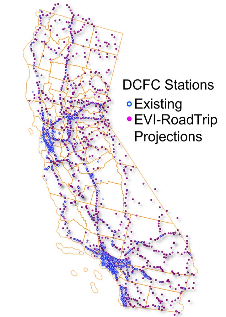
Charging Infrastructure Network Design

Next, EVI-RoadTrip designs an on-route charging station network (location of stations, the number of plugs required, and power ratings).
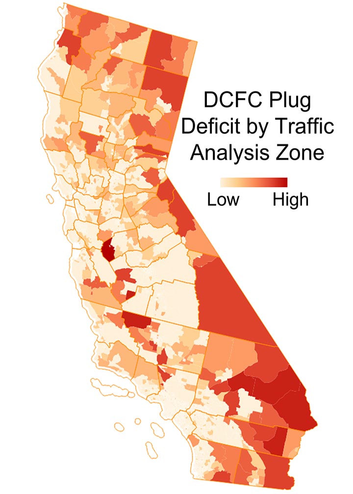
Charging Infrastructure Gap Analysis

Results from EVI-RoadTrip can inform where and how much of a gap exists in the existing charging infrastructure.
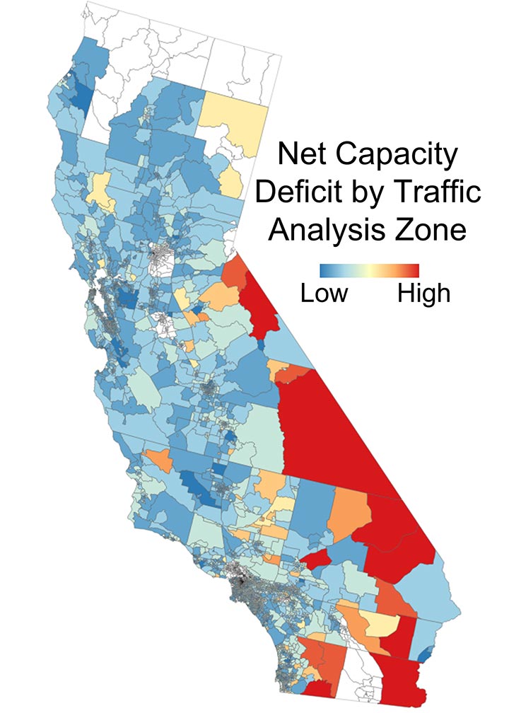
Substation-Level Electric Grid Capacity Analysis

One of the outputs of EVI-RoadTrip, EV charging load profiles for individual vehicles and charging stations, allows users to evaluate the electric grid capacity deficit.
A simplified, web-based version of the tool—EVI-RoadTrip Lite—enables U.S. states and counties to estimate the number and type of charging ports needed and associated power demands to support long-distance travel in their areas.
Publications
Fast Charging Infrastructure for Electrifying Road Trips to and From National Parks in the Western United States, NREL Presentation (2024)
California Electric Vehicle Infrastructure for Long-Distance Travel: Direct Current Fast Charging Needs To Enable Interregional Long-Distance Travel for Electric Vehicles, California Energy Commission Report (2023)
Fast-Charging Infrastructure for Electrifying Road Trips to and From National Parks in the Western United States, NREL Technical Report (2023)
DC Fast Charging Infrastructure for Electrified Road Trips, NREL Presentation (2020)
Contact
Share
Last Updated Feb. 28, 2025
